

Congratulations to Shagun Garg who has been recognised as a Geo-Spatial Rising Star 2025 at the Geospatial World Forum 2025. See the article PhD student Shagun Garg named Geospatial World Rising Star 2025 | Department of Engineering
"I’ve always been fascinated by the way data from space can help us better understand problems here on Earth. As climate change increases the severity and frequency of floods and droughts, there’s an urgent need for smarter, more scalable monitoring approaches. I want my research to directly support decision-makers—from engineers to humanitarian responders—who are working to build more resilient communities.” - Shagun Garg
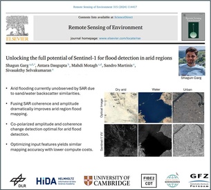
And well done to Shagun whose paper “Unlocking the full potential of Sentinel-1 for flood detection in arid regions” was published in Remote Sensing of Environment. Shagun is in his second PhD year.
When rain falls in the desert, the consequences can be devastating—flash floods sweep across what was once parched land. But detecting these floods from space has long been a challenge. Radar satellites, the gold standard for flood mapping, frequently misclassify dry sandy terrain as water, leaving large desert populations off the global flood monitoring radar—literally.
Now, a new study published in Remote Sensing of Environment shows how we can fix that. Lead author Shagun Garg, a second-year PhD student in the EPSRC Centre for Doctoral Training in Future Infrastructure and Built Environment (FIBE2 CDT), has developed a technique that improves radar-based flood detection in arid regions by up to 50%.
“Floods don’t just happen in rainforests and river deltas,” explains Shagun. “They happen in deserts, too—and when they do, they’re often catastrophic. But global flood systems tend to overlook these areas, simply because the satellite signals get confused.”
Radar backscatter from Sentinel-1 satellites makes water and dry sand appear similarly dark in the imagery, leading to frequent misclassifications (see figure below). Shagun’s method uses both the amplitude and phase information from radar signals before and after a flood event to better distinguish the two.
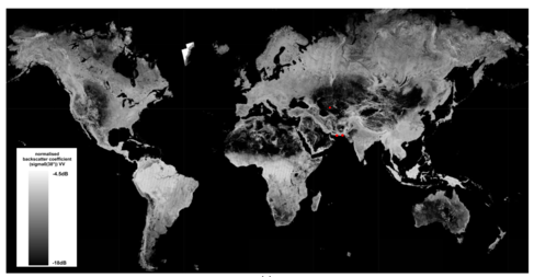
The red dots represent the case sites where the Sentinel-1 Global Backscatter Model methodology is developed and tested. Credit: https://gee-community-catalog.org/projects/s1gbm/#license
The approach was tested on recent flood events in Iran, Pakistan, and Turkmenistan, including floods caused by a dam failure. In each case, the method successfully mapped areas that previous systems missed.
“I was shocked by how underrepresented arid regions were in flood datasets. This method hopes to fill that gap—and gives decision-makers the tools they need to plan evacuations, deliver aid, and map flood risk more accurately.” - Shagun GargAs climate change increases the frequency of extreme weather, including unexpected downpours in dry zones, the need for inclusive flood monitoring systems is more urgent than ever. Shagun’s work is a timely step toward ensuring that vulnerable regions aren’t left out.
With the expanding network of Earth observation satellites and growing processing power, there’s enormous potential to build more accurate, global flood maps. This research opens the door for future systems that are faster, fairer, and more geographically inclusive.
Shagun’s work focuses on remote sensing for water management with a particular interest in evidence-based nature-based solutions for flood and drought mitigation. He is supervised by Dr Sakthy Selvakumaran and Dr. Edoardo Borgomeo. You can read more about his research on Google Scholar, and ResearchGate and find him on X (@ShagunGarg1511) and LinkedIn (https://www.linkedin.com/in/shagungarg1511/).
Reference : Garg, S., Dasgupta, A., Mahdi Motagh, Martinis, S. and Sivasakthy Selvakumaran (2024). Unlocking the full potential of Sentinel-1 for flood detection in arid regions. Remote Sensing of Environment, 315, pp.114417–114417. doi:https://doi.org/10.1016/j.rse.2024.114417.